Warnings provide individuals and communities with real time information on what is happening and what they need to do. Warnings are also sent to media outlets (radio and television) for public broadcast.
In an emergency, it is critical that information provided to the community is timely, accurate and informative. In a period of uncertainty, community anxiety and concern can be reduced by providing advice on what has happened, what needs to be done and where people can go for assistance.
Australia has implemented a nationally consistent warning system for emergencies like bushfire, flood, storm, and severe weather. This system is called the Australian Warning System (AWS).
In Tasmania, the Australian Warning System currently applies to bushfires and floods. Knowing and understanding these warning levels will help you to be better prepared to take action when the time comes. This information is available via TasALERT – Know your warnings.
What is a warning?
- Warnings will be issued on TasALERT when an emergency may impact you and your community.
- The Warnings provide you with real time information on what is happening and what you should do.
- Remember, if you think you are at risk, do not wait for an official warning to act.
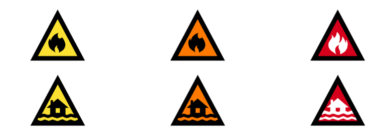
The following icons are used for bushfire and flood warnings:
What do the warning levels mean?
There are three warning levels:
Advice (YELLOW)
An incident has started. There is no immediate danger. Stay up to date in case the situation changes.
- Prepare now
- Stay informed/threat is reduced
- Monitor conditions
- Avoid the area
- Return with caution
- Avoid smoke
Watch and Act (Orange)
There is a heightened level of threat. Conditions are changing and you need to start taking action now to protect you and your family.
- Prepare to leave/evacuate
- Leave/evacuate now if you are not prepared
- Prepare to take shelter
- Move/stay indoors
- Stay near shelter
- Walk two or more streets back
- Monitor conditions as they are changing
- Be aware of ember attacks
- Move to higher ground (away from creeks/rivers/coast)
- Limit time outside (cyclone, heat asthma)
- Avoid the area
- Stay away from damaged buildings and other hazards
- Prepare for isolation
- Protect yourself against impacts of extreme heat
- Do not enter flood water
- Not safe to return
- Prepare your property (cyclone/storm)
Emergency Warning (Red)
An Emergency Warning is the highest level of warning. You may be in danger and need to take action immediately. Any delay now puts your life at risk.
Each warning level has a set of action statements to give the community clearer advice about what to do. Calls to Action can be used flexibly across all three warning levels depending on the hazard.
- Leave/evacuate (immediately, by AM/PM/hazard timing)
- Seek/take shelter now
- Shelter indoors now
- Too late/dangerous to leave
Other Warnings
Flood
| Hazard | Warning Type/Indication | Issuing Agency |
| Flood watch | Alert, Watch or Advice of possible flooding, if flood producing rain is expected to happen in the near future. The general weather forecasts can also refer to flood producing rain. | BoM |
| Flood warnings | Warnings of Minor, Moderate or Major flooding in areas where the Bureau has specialised warning systems in place. In these areas the flood warning message will identify the river valley, the locations expected to be flooded, and the likely severity of the flooding when it is likely to occur. | BoM |
| Minor flood warning | Causes inconvenience. Low-lying areas next to watercourses are inundated with water which may require the removal of stock and equipment. Minor roads may be closed and low-level bridges submerged. | BoM |
| Moderate flood warning | In addition to the above, the evacuation of some houses may be required. Main traffic routes may be covered. The area of flood inundation is substantial in rural areas requiring the removal of stock. | BoM |
| Major flood warning | In addition to the above, extensive rural areas and/or urban areas are inundated with water. Properties and towns are likely to be isolated and major traffic routes likely to be closed. Evacuation of people from flood affected areas may be required. | BoM |
Severe weather
| Hazard | Warning Type/Indication | Issuing Agency |
| Severe weather warnings | These warnings are provided when severe weather is expected that is not directly related to severe thunderstorms, tropical cyclones or bushfires. Examples include land gales, squalls, flash-flooding, dangerous surf or tides. | BoM |
| Damaging winds | Gusts expected in excess of 100 km/h (75 km/h when wind is from the east or south – i.e. an unusual direction), or destructive winds above 125 km/h. | BoM |
| Damaging surf | Issued when swell is expected to exceed 6 metres about the north and east coasts, and 7 metres about the southeast coast. | BoM |
| Abnormally high tides | Issued when tides are expected to be sufficiently high to cause damage to foreshore areas or disruption to foreshore and maritime activities (generally when water level expected to reach 40cm above normal spring tide level). | BoM |
| Very heavy rain that may lead to flash flooding | Issued when the rainfall rate over one hour is expected to exceed the one in 5 or 1 in 10-year return period. | BoM |
| Severe thunderstorm warnings | Issued when thunderstorms are expected to produce dangerous or damaging conditions: hail greater than 2cm diameter; wind gusts greater than 100 km/h; flash flooding; tornadoes | BoM |
| Bushwalkers weather alert | Issued when conditions are likely to pose a danger to bushwalkers – generally cold, wet, windy weather. | BoM |
| Heatwave | Issued when heatwave conditions are forecast. Warning provides information on preparing for and coping with extreme heat. | DoH |
| Ice and frost on roads | Road weather alerts to advise of potentially dangerous driving conditions e.g. fog, low visibility in heavy rain, gusty winds, widespread frost, snow. | BoM |
Fire
| Fire weather warning | Issued when the rating on the fire danger scale is expected to exceed thresholds agreed to with fire agencies i.e. when forest fire danger index exceeds 38 in Tasmania. | BoM |
Smoke alert | Provides information about smoke from a fire, bushfire or fuel reduction burn that may impact a community or areas of Tasmania. | TFS |
No Rating (FBI 0-11) | On days of minimal risk, no rating will be issued. Action: Fires may start but are unlikely to spread in a fast or threatening way. | TFS |
Moderate Fire Danger Rating (FBI 12 – 23) | Plan and Prepare Most fires can be controlled. Action: Stay up to date and be ready to act if there is a fire. | TFS |
High Fire Danger Rating (FBI 24 – 49) | Be Ready to Act Fires can be dangerous Action: There’s a heightened risk. Be alert for fires in your area. Decide what you will do if a fire starts. If a fire starts, your life and property may be at risk. The safest option is to avoid bush fire risk areas. | TFS |
Extreme Fire Danger Rating (FBI 50 – 99)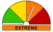 | Take action now to protect your life and property. Fire will spread quickly and be extremely dangerous. Action: These are dangerous fire conditions. Check you bushfire plan and that your property is fire ready. If a fire starts, take immediate action. If you and your property are not prepared to the highest level, go to a safer location well before the fire impacts. Reconsider travel through bush fire risk areas. | TFS |
Catastrophic Fire Danger Rating (FBI 100+)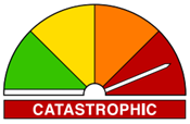 | For your survival, leave bush fire risk areas If a fire starts and takes hold, lives are likely to be lost Action: These are the most dangerous conditions for a fire. Your life may depend on the decisions you make, even before there is a fire. Stay safe by going to a safer location early in the morning or the night before. Homes cannot withstand fires in these conditions. You may not be able to leave and help may not be available. | TFS |